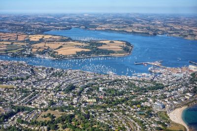
Looking down over Falmouth from about 1,500 feet. This view takes in most of the town, bar Pendennis Head, and gives some idea of the layout of the River Fal. To the bottom right of the photo is Gyllyngvase beach - Falmouth's finest.
Most of the old part of town is concentrated along the riverfront which overlooks the town's vast natural harbour. The headland separating the two bodies of water is home to the waterside villages of Flushing and Mylor. The water on the far side of this is the Carrick Roads, a natural deep water harbour which usually has a number of huge container ships and tankers anchored in it.
From the Carrick Roads the river takes to branches; Restronguet Creek which goes to the left of the photo, and the River Fal proper which heads northwards towards Truro.


