St Breock, along with Egloshayle, was one of the original parishes out of which Wadebridge developed. Bounded on the north and east by the River Camel, the parish is named after St Briocus, who originated from Ireland but had strong associations with Brittany.
The parish church, which contains interesting monuments to the Tredeneck family, dates back to the thirteenth century, although it was extensively rebuilt in 1677. The church suffered major flood damage in 1965 due to its position by a stream at the bottom of a valley. The area that is now St Breock appeared in the Domesday Book as part of Pawton, a large manor that belonged to the bishops of Exeter and included six whole parishes and bits of four others. The manor of Pawton was already established in Saxon times and the faint remains of the bishop's palace and a deer park are recorded as being still visible in 1925.
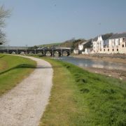
The parishes of St Breock and Egloshayle were connected by a dangerous ford until 1485 when Thomas Lovebound, the Vicar of Egloshayle, oversaw the construction of a bridge. The bridge, which is three hundred and twenty feet long and has fifteen arches, is still in use today.

Cornwall's largest and heaviest prehistoric monument, a standing stone that would have originally stood five meters high and weighed an astounding seventeen tonnes, still tops St Breock Downs, which offer spectacular views of the surrounding coast and countryside. Other evidence of early settlement includes a fifth century inscribed pillar stone at Nanscombe Farm.
The village of St Breock is on the east side of the wooded Nansent Valley, immediately south of the Royal Cornwall Showground.